9 European engagement with the Australian continent
European exploration of Australia was prompted by hope, and that hope was generally betrayed by reality. Recognizing the shape of the real continent took time and involved disappointment. European explorers of Australia were guided by the experiences of explorers in other parts of the world: their lack of knowledge about the physical conditions of the continent misled them, and they grasped at any evidence that promised to support their preconceived ideas of abundant resources waiting to be exploited. Despite generally returning without rich discoveries to report, explorers have long been seen as heroes who suffered in pursuit of knowledge. As a result, the achievements of those explorers who succeeded in mapping out large regions are often less well known than the experiences of those who suffered through their encounters with the Australian continent.
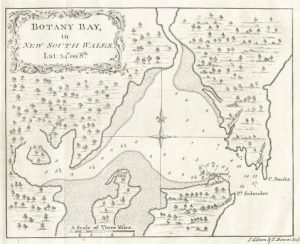
Sydney was founded on the basis of the Endeavour’s reports of conditions at Botany Bay, and those reports were misleading. The Endeavour spent eight days in the Botany Bay region in April and May 1770. James Cook reported the presence of woods, lawns, marshes, grazing animals and tall trees to provide good timber. He praised the prospect of easy cultivation given the lack of undergrowth, and the quality of the soil. While Cook encountered the country’s Traditional Owners throughout his stay, he considered the population of the area to be sparse. Cook’s report of the region—with lush grass, full creeks, and few people—was not the experience of the convict settlers who arrived in January 1788. But the failure of reality to live up to expectation in the case of the first region of Australia to be settled did not deflate European hopes for the interior.
The physical size of the Australian continent has often been misinterpreted as an indication of economic potential. Much larger than Europe, and only fractionally smaller than North America, the potential indicated by Australia’s expanse is undermined by its lack of rain. Australia is the world’s driest inhabited continent, and large areas are barely populated because they are too dry to support sizeable human populations and their endeavours. However, the early European explorers of Australia were not in a position to predict that rain did not fall over most of the continent on a reliable basis. Instead, the location of Sydney made a number of rivers visible to settlers. That those rivers were smaller than might be expected did not lead to the conclusion that comparatively little rain fell on the continent, instead it led to speculation about where the continent’s waters might be found.
European experiences in the exploration of other continents reinforced expectations that exploration in Australia would both reveal rivers and be aided by them. In North America European explorers had earlier exploited rivers, including the Mississippi, Missouri, and Dehcho (Mackenzie River), finding them navigable and valuable. In Africa, exploration occurring at much the same time as the European exploration of Australia made use of the Niger, Zambezi, and Congo as routes into the interior of the continent. For explorers, rivers held the prospect both of relatively easy travel and of the well-watered lands they wished to find.
It was logical for explorers within Australia to seek to use rivers as a way of locating useful resources and penetrating the inland. In 1817 John Oxley led an expedition to trace the course of the Lachlan River. In 1818 he set out along the Macquarie River. In both instances he found his way blocked by impenetrable marshland. Oxley concluded that the Australian interior was useless marsh, but rivers continued to offer explorers hope that the Australian continent could be profitably explored.
In late 1828 Charles Sturt set off during a drought to explore the marshlands located by Oxley. He located a river he named the Darling, part of Australia’s most extensive river system. However, the drought had shrunk the Darling and what water it contained was salty. He returned to explore further in late 1829, and encountered other rivers within the Murray-Darling Basin including the Murrumbidgee. Expecting to be able to use rivers to explore, Sturt had brought a whale boat with him. He was able to use it to explore the Murrumbidgee and reach a river he renamed the Murray (as well as having Indigenous names, the river had been named the Hume River in 1824) which he followed to Lake Alexandrina (very nearly the sea). Sturt and his men suffered considerable hardships, and located southeast Australia’s significant river system. While Sturt’s account led to further settlement in the region, in comparison to the great rivers of other continents the Murray-Darling is long, but does not carry a large amount of water, or support a large human population.
Thomas Mitchell, a pragmatic and efficient surveyor and explorer, continued official exploration in the interior of New South Wales. Several of Mitchell’s expeditions were prompted by the hope of a large river flowing north from northern New South Wales. Such a river would provide both an explanation of where the rain expected to fall to the west of the Great Dividing Range went, and a convenient route between New South Wales and India. In 1831 Mitchell led an expedition in part prompted by the account of a recaptured convict, George Clarke. Clarke had spent time with Aboriginal people, and claimed to have seen the ‘Kindur’, a great river that flowed north. While Clarke’s testimony was not consistent across his various interviews with colonial authorities, it accorded with expectations at the time that Australia’s large rivers remained undiscovered. However, on his 1831 expedition, Mitchell ascertained that the Kindur did not exist. In 1835 Mitchell set off again hoping to find that the Darling led north. He discovered that it did not, although he set out again in 1836 to more fully explore the Murray and the Darling. In 1845, after spending time in England, Mitchell again set out hoping to find Australia’s great, northward flowing river. This time he located a river he named the Victoria, which he thought ran north. Further investigation by Edmund Kennedy in 1847 found that river (the Barcoo) turned south and joined Cooper Creek, ultimately draining into Lake Eyre.
Speculation about the prospect of as-yet-unknown rivers enriching and unlocking the Australian continent, coupled with subsequent disappointment, was not limited to the east of the continent. In the west, George Fletcher Moore, a settler interested in Noongar language and culture, considered the absence of large rivers combined with Aboriginal stories to be convincing evidence of a nearby inland sea. He published the book Evidences of an Inland Sea in 1837. In 1836-7 and 1839 George Grey led two expeditions in Western Australia looking for the western equivalent of the Murray River. Despite Dutch explorers earlier rejecting the potential of western Australia, Grey hoped to find a well-watered interior, fed by the rivers that had not been found entering the ocean. Grey was enthusiastic about his finds, but the rivers and pastures he located were seasonal, and no western version of the Murray exists.
In 1844 Sturt set off from Adelaide, and took with him a boat to sail the inland sea. Sturt’s belief in the existence of an inland sea was unusual, and other explorers and geographers tended to pin their hopes for the Australian continent on large rivers, rather than an extensive lake. Sturt’s expedition travelled as far as Sturt’s Stony Desert, but even there the prospect of Australia’s inland sea did not completely evaporate. Faced with the desert, Sturt consoled himself with the thought that while the inland sea might not exist anymore, it had existed in the distant past. He also expressed hope that it might still exist further north. Those hopes were finally destroyed by the crossing of the Australian continent in 1860. The parallel expeditions of Burke and Wills and John McDouall Stuart crossed the continent from south to north and confirmed the absence of permanent large rivers and lakes.
Overall, European explorers in Australia did not find what they were looking for. Australia’s limited and unreliable rainfall makes it an unusual continent. Long, large, and navigable rivers unlocking a hinterland with agricultural potential do not exist in Australia as they do in other continents. Near the Australian coast there are well-watered pastures and well-timbered forests, but they had been quickly located by European surveyors and colonists. Exploration continued, but in many ways it became a test of hardiness and the ability to suffer in pursuit of a noble aim rather than an economic project.
Links
Explorer journals
Carron, William. Narrative of an Expedition: Undertaken Under the Direction of the Late Mr. Assistant Surveyor E.B. Kennedy, for the Exploration of the Country Lying Between Rockingham Bay and Cape York. Sydney: Kemp and Fairfax, 1849. https://collection.sl.nsw.gov.au/record/74VvzvPMLvkA/k57QaoqkQWy0R
Grey, George. Journals of Two Expeditions of Discovery in North-west and Western Australia, During the Years 1837, 1838, and 1839, Under the Authority of Her Majesty’s Government. London: T. and W. Boone, 1841. https://gutenberg.net.au/ebooks/e00054.html
Moore, George F. Evidences of an Inland Sea: Collected from the Natives of the Swan River Settlement. Dublin: William Curry, Jun. and Company, 1837. https://digital.sl.nsw.gov.au/delivery/DeliveryManagerServlet?embedded=true&toolbar=false&dps_pid=IE4715573&_ga=2.155446267.1329621176.1643239144-500205100.1638851852
Oxley, John. Journals of Two Expeditions into the Interior of New South Wales, by order of the British government in the years 1817-18. London: John Murray, 1820. https://gutenberg.net.au/ebooks/e00037.html
Papers relating to the Burke and Wills Expedition, 1860-1861
Stuart, John McDouall. The Journals of John McDouall Stuart During the Years 1858, 1859, 1860, 1861, and 1862, When he Fixed the Centre of the Continent and Successfully Crossed it from Sea to Sea. Edited by William Hardman. 2nd ed. London: Saunders, Otley, and Co., 1865. https://www.gutenberg.org/files/8911/8911-h/8911-h.htm
Sturt, Charles. Narrative of an Expedition into Central Australia Performed under the Authority of Her Majesty’s Government during the Years 1844, 5, and 6 Together with a Notice of the Province of South Australia in1847. London: T. and W. Boone, 1849. https://setis.library.usyd.edu.au/ozlit/pdf/p00102.pdf
Maps
Video material
Open access secondary sources
Graves, Matthew and Elizabeth Rechniewski. “Mapping Utopia: Cartography and Social Reform in 19th Century Australia.” PORTAL, 9, no. 2 (July 2012): 1-20. https://epress.lib.uts.edu.au/journals/index.php/portal/article/view/2147/2897
Hercus, Luise, Flavia Hodges, Jane Simpson (eds). The Land is a Map: Placenames of Indigenous Origin in Australia. Canberra: ANU Press. http://doi.org/10.22459/LM.03.2009
Powell, Owen. “Great Artesian Basin: Water from Deeper Down”, Queensland Historical Atlas. Updated February 25, 2011. https://www.qhatlas.com.au/great-artesian-basin-water-deeper-down
Other secondary sources
Boyce, Dean. Clarke of the Kindur: Convict, Bushranger, Explorer. Melbourne: Melbourne University Press, 2013.
Cathcart, Michael. The Water Dreamers: The Remarkable History of our Dry Continent. Melbourne: Text Publishing Company, 2009.
Cook, Karen S. “Thomas John Maslen and ‘The Great River or Desired Blessing’ on His Map of Australia.” Globe 61 (2008): 11-20.
McLaren, Glen. Beyond Leichhardt: Bushcraft and the Exploration of Australia. Perth: Fremantle Arts Centre Press, 1996.
