7 Europeans begin to explore the Australian continent
European exploration of the Australian continent mostly followed colonisation, rather than colonisation following exploration: when Sydney was founded in 1788 not even the outline of the continent was fully known. At that time, for Europeans, there was the possibility that New South Wales (the eastern edge of which had been mapped by James Cook) was not the same landmass as New Holland (the western portion of the continent, with a coastline in part mapped by Dutch navigators). The Sydney settlement was slow to spread inland, and in its early years was more tightly tied to the Pacific on its doorstep than to its continental hinterland. As other British colonies were established on the continent that pattern was repeated: colonisation led to exploration, not the other way round.
As the edges of the Australian continent were being charted by ocean-going explorers and voyagers, the continental interior remained a blank space on European maps. Famously, James Cook produced a detailed map of large portions of the east coast during his 1770 voyage along it, and by the time of Cook’s Endeavour voyage portions of the north, west, and south coasts had been surveyed and partially mapped by a variety of European explorers. The establishment of Sydney did not immediately lead to increased European knowledge of the continent. A quirk of geography meant that the settlement was able to spread only a short way inland before being caged in by the hills and mountains of the Great Dividing Range. The settlement initially spread to encompass the welcoming, coastal Cumberland Plain, but then faced significant barriers before it could tap into resources further inland. Early Sydney sought its supplies in Tahiti and Aotearoa (New Zealand) and those vital connections confirmed the colony’s position: it was a coastal rather than a continental settlement, and the Pacific on its front door step was of greater significance to its survival than the continent behind it.
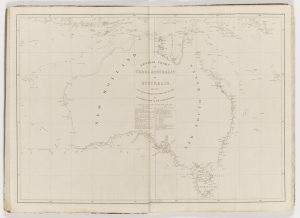
Once Sydney was established as a European base, coastal exploration of the Australian continent intensified. In 1795 coastal exploration to Sydney’s south by Matthew Flinders and George Bass established that the scrap of coast mapped by Tasman (named Van Diemen’s Land) was part of an island (in 1856 that island became a colony separate from New South Wales and officially took the name Tasmania). The charting of Bass Strait (between Van Diemen’s Land and the continent) promised quicker transit from Britain to Sydney by sea. Between 1801 and 1803 Flinders captained an expedition that undertook the first close circumnavigation of the Australian continent. His journal and the map he constructed were not published until 1814. They contained the first clear map of the coast of the Australian continent, and a proposal that it be named ‘Australia’. As a result of Flinders’ 1801-3 voyage it was finally clear what landmass was in the process of being colonised by the British, although that map only clarified the coast, and left the inland almost entirely blank.
The settlement of Sydney soon sought to break out of the Cumberland Plain, but European explorers struggled to find a way through the Great Dividing Range—that extensive range of mountains and hills that divides the east coast of Australia from the interior and that marks the watershed of the eastern continent. The settlers of Sydney had made multiple attempts to find a way through the Blue Mountains to the settlement’s west, but only succeeded in 1813. Once that barrier had been successfully crossed (25 years after the establishment of the Sydney colony), European exploration of the interior could begin.
British interests had not waited for exploration of Sydney’s hinterland before establishing other colonial outposts along the continent’s coast. In 1802 the British formalised their claim to Van Diemen’s Land, in response to concerns about the motives behind Nicholas Baudin’s expedition, a French circumnavigation of the Australian continent that occurred at the same time as Flinders’. British claims to that island were then cemented with the sending of convicts to the Derwent River to establish an outpost in 1803, and the establishment of a second convict settlement on the Tamar River in 1804. Both settlements had unknown hinterlands when established, and were only connected by an overland route in 1807.
In 1823 the Brisbane River and Moreton Bay region were mapped by John Oxley, and again British claims were cemented by dispatching convict settlers. A first attempt at European settlement in the region was made in 1824 at Moreton Bay, but that settlement needed to be relocated in 1825, at which time it was renamed Brisbane. In 1826 a military outpost was established at Albany in the southwest of the continent, and in 1827 Britain claimed the west of the continent, sending convicts to establish a settlement at King George Sound. In 1827 the Swan River was explored, and Perth was established in 1829 as a free settlement (it became a penal settlement in 1849). Similarly, the region that is now South Australia was not staked out using convicts, but still followed the typical Australian pattern of settlement being followed by exploration, rather than the other way around. As did Victoria: Melbourne was first established in 1835 by private settlers. When Australia’s colonies were first established they were fictions and hopes marked onto maps, they did not reflect real European control of the region being claimed.
Once planted, settlements promoted exploration as they sought resources to become self-sustaining. Many European exploring expeditions were pragmatic in their aims: they sought to locate reliable water sources, to map rivers to unlock routes into the interior and provide reliable means of transport, to locate good pasture (generally in association with rivers), and sometimes to locate other natural resources, including minerals. This process was repeated at each new settlement, and those settlements were at first connected by coastal shipping, not by overland routes. The frontiers of European settlement spread inland slowly and unevenly. In Australia, often the frontier spread independently of government control as pastoralists sought resources for their animals while government survey and official land alienation trailed behind.
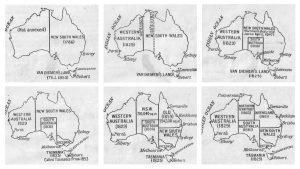
Cook’s New South Wales came to be divided among the emerging colonies, reflecting the progress of European settlement on the Australian continent. The settlements in Tasmania had occurred early in the colonial process, and in 1825 Van Diemen’s Land separated from the colony of New South Wales. In 1829 Western Australia was proclaimed as a colony, the only Australian colony to form without taking land from New South Wales. In 1834 the province of South Australia was officially proclaimed. In 1841 New Zealand formally separated from New South Wales, following the 1840 signing of the Treaty of Waitangi. In 1851 Victoria separated from New South Wales as European settlement there intensified. And in 1859 Queensland separated from New South Wales. Those dates, while referring to political acts, reflect the staggered arrival of the frontier in different regions of Australia.
But even as settler Australia divided up the continent, it was not not fully explored and known by Europeans. By the late nineteenth century the hope of finding new pastoral regions was dead, and exploration instead used science for its rationale. The difficulties of travelling through the extensive arid regions of the continent (and the lack of tangible rewards for doing so) meant that significant geographical features of the Australian continent remained unknown until the advent of aerial photography. The aerial photographic survey of Lake Eyre in 1922 was a logistical feat, and a milestone in beginning to finalise the map of the interior of the Australian continent. Aerial surveys revealed significant landscape features previously unknown to Europeans, but no new fertile regions came to light. Australian settlement remains largely restricted to narrow bands along portions of the continent’s coast and aerial mapping has finally destroyed the prospect of Australia being the lavish southern continent long imagined by Europeans.
Links
Explorer journals
Blaxland, Gregory. A Journal of a Tour of Discovery Across the Blue Mountains, New South Wales, in the Year 1813. Sydney: Gibbs, Shallard and Co, 1870. https://setis.library.usyd.edu.au/ozlit/pdf/p00011.pdf
Flinders, Matthew. A Voyage to Terra Australis Undertaken for the Purpose of Completing the Discovery of that Vast Country, and Prosecuted in the Years 1801, 1802 AND 1803, in His Majesty’s Ship the Investigator, and Subsequently in the Armed Vessel Porpoise with Cumberland Schooner. With an Account of the Shipwreck of the Porpoise, Arrival of the Cumberland at Mauritius, and Imprisonment of the Commander During Six Year and a Half in that Island. https://www.gutenberg.org/ebooks/12929 Vol I. London: G. and W. Nicol, 1814
Flinders, Matthew. A Voyage to Terra Australis Undertaken for the Purpose of Completing the Discovery of that Vast Country, and Prosecuted in the Years 1801, 1802 AND 1803, in His Majesty’s Ship the Investigator, and Subsequently in the Armed Vessel Porpoise with Cumberland Schooner. With an Account of the Shipwreck of the Porpoise, Arrival of the Cumberland at Mauritius, and Imprisonment of the Commander During Six Year and a Half in that Island. London: G. and W. Nicol, 1814. https://www.gutenberg.org/ebooks/13121 Vol II
Fraser, C., J. G., Hay, and A. H. Gilbert. The Visit of Charles Fraser (the Colonial Botanist of New South Wales): to the Swan River in 1827, with His Opinion on the Suitableness of the District for a Settlement. Perth: J. G. Hay, 1906. https://viewer.slv.vic.gov.au/?entity=IE4172934&mode=browse
Madigan, C. T. “Lake Eyre, South Australia.” The Geographical Journal 76, no. 3 (1930): 215–40. https://doi.org/10.2307/1784797
An Officer. An Authentic Journal of the Expedition Under Commodore Phillips to Botany Bay : With an Account of the Settlement Made at Port Jackson and a Description of the Inhabitants, &c. With a Copy of a Letter from Captain Tench of the Marines; and a List of the Civil and Military Establishment, to which is Added an Historical Narrative of the Discovery of New Holland, or, New South Wales. London: C. Forster, 1789. http://nla.gov.au/nla.obj-185960141
Oxley, John. Journals of Two Expeditions into the Interior of New South Wales Undertaken by Order of the British Government in the Years 1817-18. London: John Murray, 1820. https://setis.library.usyd.edu.au/ozlit/pdf/p00066.pdf
Maps and online resources
Australian Government Bureau of Meteorology. Australian Hydrological
Geospatial Fabric (Geofabric). 2012.
“Burke and Wills Web Digital Research Archive.” Last updated 2020.
Geoscience Australia. “Aerial Photography Through Time.” Accessed March 22, 2022.
Irish, Paul. Dyarubbin, the Hawkesbury-Nepean River: catchment and surrounding regions 2020. 2020.
Video material
Open access secondary sources
Museum of Australian Democracy. “Places.” Accessed March 22, 2022. https://www.foundingdocs.gov.au/places.html
National Museum of Australia. “Flinders Circumnavigates Australia.” Accessed March 22, 2022. https://www.nma.gov.au/defining-moments/resources/flinders-circumnavigates-australia
Phoenix, David Gary. “‘More like a Picnic Party’: Burke and Wills: An Analysis of the Victorian Exploring Expedition of 1860-1861.” PhD thesis, James Cook University, 2017. https://researchonline.jcu.edu.au/50833/
Other secondary sources
Ballantyne, Tony. “Mobility, Empire, Colonisation.” History Australia 11, no. 2 (2014): 7-37.
Estensen, Miriam. The Life of Matthew Flinders. Crows Nest, N.S.W.: Allen & Unwin, 2002.
Karskens, Grace. The Colony: A History of Early Sydney. Crows Nest, N.S.W.: Allen & Unwin, 2009.
Lloyd, Rohan. “An Extraordinary Barrier: European Exploration, Shipwrecks and the Origins of Heritage Values on the Great Barrier Reef 1770-1860.” History Australia 17, no. 1 (2020): 40-58.
Williams, Glyndwr, and Alan Frost (eds). From Terra Australis to Australia. Oxford: Oxford University Press, 1988.
