2 Europeans reach the Pacific
Europe does not border the Pacific, and reaching the Pacific Ocean required European explorers to either pass around or across the Americas, to navigate around the tip of Africa and through the Indian Ocean, or to traverse Asia by land. Despite the significant obstacles, and the length of the journey from Europe to the Pacific, it was not long after Christopher Columbus crossed the Atlantic that Europeans began to explore the Pacific Ocean.
European determination to reach the wealth of Asia had led Columbus to ‘voyage west to reach the east’, a voyage sponsored by the Spanish monarchs Ferdinand of Aragon and Isabella of Castile in 1492. Columbus had previously promoted his ambition to reach China by sailing west to other European monarchs, but they had not supported his plans. Those monarchs were unenthusiastic not because of the prospect of sailing off the edge of a flat earth, but because they were reliably informed that Columbus had miscalculated the circumference of the world, and as a result had significantly underestimated how far he would have to sail to reach Asia.
When Columbus returned from his first voyage, he was convinced he had succeeded with his plan. How long he remained convinced of an Asian landfall is disputed by historians, and he may not have realised he had found something new and unexpected even after his fourth return voyage across the Atlantic. The prospect of having discovered a ‘New World’ (a term used to refer to the Americas, and one that distinguishes it from the ‘Old World’ of Europe, Asia, and Africa) was difficult to grasp as it seemed to contradict both the Christian Bible and previously trusted authorities on the structure of the world.
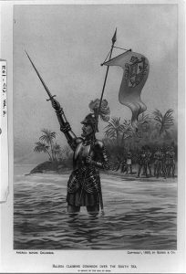
Despite this cosmological discombobulation, the Spanish moved quickly to try and find ways to profit from the newly encountered regions: colonisation and conquest followed contact. Columbus first encountered the Americas in 1492, and he attempted to found a European settlement on the island of Hispaniola during that first voyage. Further contact followed, and a permanent settlement was established on the island in 1496. With a foothold established in the Caribbean, the Spanish then attempted to colonise the mainland. It was by travelling over land that the Spanish first reached the Pacific: Vasco Nunez de Balboa led an expedition that crossed the Darien Isthmus in 1513, looking for the great ocean local people had told him about. That isthmus is the present-day site of the Panama Canal and is a narrow strip of land that separates the Pacific from the Atlantic Ocean. On 29 September 1513 Balboa waded into the saltwater of the Gulf of San Miguel to claim the ‘southern’ sea for Spain (by a quirk of geography the Darien Isthmus runs east to west, and Balboa was facing south when he first saw the Pacific: the origin of the term the South Seas).
Spanish interest in the Americas continued to increase throughout the sixteenth century, and other Spanish conquistadors made their way to the Pacific coasts of Mexico and Peru. Between 1519 and 1521 Hernan Cortes famously conquered the vast Aztec empire. He then went on to claim approximately 500 leagues of the shores of the South Sea in 1594, and to explore along the Californian coast in 1539. In the early 1530s Francisco Pizarro emulated Cortes by conquering the Incan empire in Peru. That empire was oriented towards the Pacific, with mountains blocking the coastal plain from the interior of the South American continent. Pizarro’s successful campaign exploited coastal connections, cementing the significance of overland routes to the Pacific. The conquest of Peru was linked to that first glimpse of the Pacific by the Spanish: Pizarro had been a member of Balboa’s 1513 expedition.
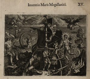
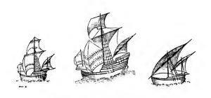
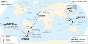
Despite these overland routes, it is the 1519 voyage of Ferdinand Magellan that is commonly associated with the entry of Europeans into the Pacific. Magellan entered the Pacific after working his way through the Straits of Magellan in the far south of South America. Magellan’s voyage left Europe with 237 members and five ships; by the time it returned to Europe at the end of its circumnavigation, it consisted of 35 men and one ship, and Magellan himself was not among the circumnavigators. He had been killed during a battle with an indigenous ruler in the Philippines, possibly as the result of a plot by an enslaved member of his expedition, Enrique. Enrique may well have been the first person to circumnavigate the planet: while not originally from the Philippines, Enrique was Malay. He was able to communicate with local people in the Philippines because he had returned to a trading region that stretched through southeast Asia.
Despite the horrors of Magellan’s voyage, which included inadequate rations, scurvy, mutiny, the desertion of a ship while the expedition was still in the Atlantic, the violent death of the captain, and conflict with the Portuguese in the Spice Islands, the voyage made a profit by returning with a ship loaded with spices. Of significance for the subsequent history of European exploration of the Pacific, Magellan’s expedition marked the Straits of Magellan on European maps, creating a sea route from Europe to the new ocean. And Magellan’s voyage marked the first circumnavigation of the world by Europeans, a remarkable event.
In the wake of Magellan other Spanish navigators sailed the Pacific. Some entered through the Straits of Magellan, thought to offer a narrow passageway between the Americas and the Southern Continent. Other navigators travelled a familiar route between Acapulco (in Mexico) and Manila (in the Philippines) as Spanish colonists in South and Central America sought to convert American silver into the desirable Asian goods that had prompted Columbus’s first voyage. The ships that sailed this annual trading mission along known latitudes were collectively known as the Manila Galleon, and the route was regularly employed between 1565 and 1815 (a period of 250 years). The wealth extracted from the Americas by the Spanish, and its concentration on board these ships, served to entice navigators of other nations into the Pacific.
Exploration of the Pacific in the period immediately after Magellan’s voyage was conducted by captains employed by Spanish monarchs (or by their representatives in South America). It was limited in extent, and in the knowledge of the Pacific it generated. Voyages set off directly from Spain or departed from Spanish Peru, but difficulties in determining longitude meant that the Pacific could not be accurately charted. The route of the Manila Galleon in the north Pacific did not lead to new knowledge of the region as captains followed known routes along known latitudes precisely to avoid contact with the unknown.
However, the Pacific was not to remain (from the European perspective) a ‘Spanish Lake’. The prospect of crossing the Pacific to access the known wealth of Asia, the presence of American gold and silver concentrated on Spanish vessels or in Spanish coastal settlements, and the persistent myth of a treasure-laden Southern Continent, served to draw other navigators to the region.
Links
Explorer Journals
Columbus, Christopher. The Journal of Christopher Columbus During his First Voyage, 1492-93. Translated by Clements R. Markham. London: Hakluyt Society, 1893. https://www.latinamericanstudies.org/columbus/Columbus-Journal.pdf
Pigafetta, Antonio. The First Voyage Round the World, by Magellan. London: Hakluyt Society, 1874. https://archive.org/details/firstvoyageroun00pigagoog/page/n10/mode/2up
Maps
Herrera y Tordesillas, Antonio de. Descripcion de las Indias Ocidentalis. 1628
Homem, Lopo. Miller Atlas: Portuguese Hemisphere. 1519
Ortelius, Abraham. “Typus Orbum Terrarum” in Theatrum orbis terrarum. 1570
Video material
Open access secondary sources
Bankoff, Greg. “Winds of Colonisation: The Meterological Contours of the Spain’s Imperium in the Pacific 1521-1898.” Environment and History 12 (2006): 65-88, https://www.researchgate.net/publication/233684663_Winds_of_Colonisation_The_Meteorological_Contours_of_Spain’s_Imperium_in_the_Pacific_1521-1898
Brooke-Hitching, Edward. “The Lie of the Land: When Map Makers get it Wrong—in Pictures.” Guardian, November 16, 2016, https://www.theguardian.com/books/gallery/2016/nov/16/the-lie-of-the-land-when-map-makers-get-it-wrong-edward-brooke-hitching-in-pictures
GeoGarage blog, “South Pacific Sandy Island ‘Proven not to Exist’.” Last updated November 22, 2012. https://blog.geogarage.com/2012/11/south-pacific-sandy-island-proven-not.html
Spate, O.H.K. The Spanish Lake. Canberra: ANU Press, 2004. http://doi.org/10.22459/SL.11.2004
Other secondary sources
Camino, Mercedes Maroto. Producing the Pacific: Maps and Narratives of Spanish Exploration 1567-1606. Kenilworth: Rodopi, 2005.
